Those of us who love great hiking and cycling routes envy the enormous infrastructure of this type that exists north of the Pyrenees. The German rivers, for example, be they the Elbe, the Rhine or the Danube, carry parallel cycle paths of hundreds and hundreds of uninterrupted kilometres, also created with those who use bicycles or walkers in mind. Just as happens, for example, in the Netherlands, France or Austria. However, having them, we have them. Another thing is that its usefulness is light years away from those. Without going further, there is the Tagus Natural Path, of which the vast majority of fellow citizens do not know its existence. Yes, there is a route of over 800 kilometers parallel to or close to the great Spanish-Portuguese river, marked by the Ministry of Agriculture, Fisheries and Food with white and red signs, which goes from its source in the Montes Universales to the border with Portugal.
Its very existence is already a commendable achievement, I must admit. But the user of a route like this not only needs it to be signposted, but also needs to have facilities within reasonable distances where they can eat, sleep, shelter or repair their bicycle if traveling in this environment. And Spanish long-distance routes suffer from all this, and this is no exception. It’s nonsense that bites its tail: if the Administration doesn’t take charge of the infrastructure, users won’t go, but if once built very few users use it, no one can afford to set up services at the foot of the road, be it a rural house, a restaurant or a bicycle rental… and the landscape ends up being so barren that everything collapses. In central and northern Europe there are many more fans and, therefore, services.
The Tajo natural trail is a good example. It passes through places of exceptional ecological value, such as the Alto Tajo Natural Park at the beginning, the Monfragüe National Park, the meadows of Extremadura, the Villuercas mountain range… And through historic cities such as Aranjuez, Toledo or Talavera de la Reina. But there are no infrastructures to welcome the traveler other than those of the cities through which he passes. And there can be – and indeed there are – many kilometers between one and the other. Which complicates the logistics, especially if you walk.
Despite everything, the first five stages along the incipient riverbed of the Tagus are a delight that I recommend to every cycle touring enthusiast.
The Tajo originates in Fuente García, municipality of Frías de Albarracín (Teruel), in the Universal Mountains. It is possible to start the route from here, but it is a lonely place where it is not advisable to arrive or return for support cars – this route is linear. The Natural Trails signage starts much earlier, in Albarracín, a beautiful, very touristy town in Teruel where it is easier to organize the arrival and return of the vehicle. Albarracín is not located in the bed of the Tagus, but in a bend of the Guadalaviar river, which will later be called Turia. The Nature Trail begins on the outskirts of this town of Teruel and continues through the Guadalaviar valley to its source, passing through Torres de Albarracín and Villar del Cobo.
From Fuente García, the signs will lead you to an area of pine forests and prairies that are as solitary as they are beautiful. For many kilometers of stages 2 and 3 you do not cross any inhabited area. We are now in the province of Guadalajara, in the heart of the most rural and uninhabited Spain. The famous Spain emptied. And just stop by here to find out why it’s called that.
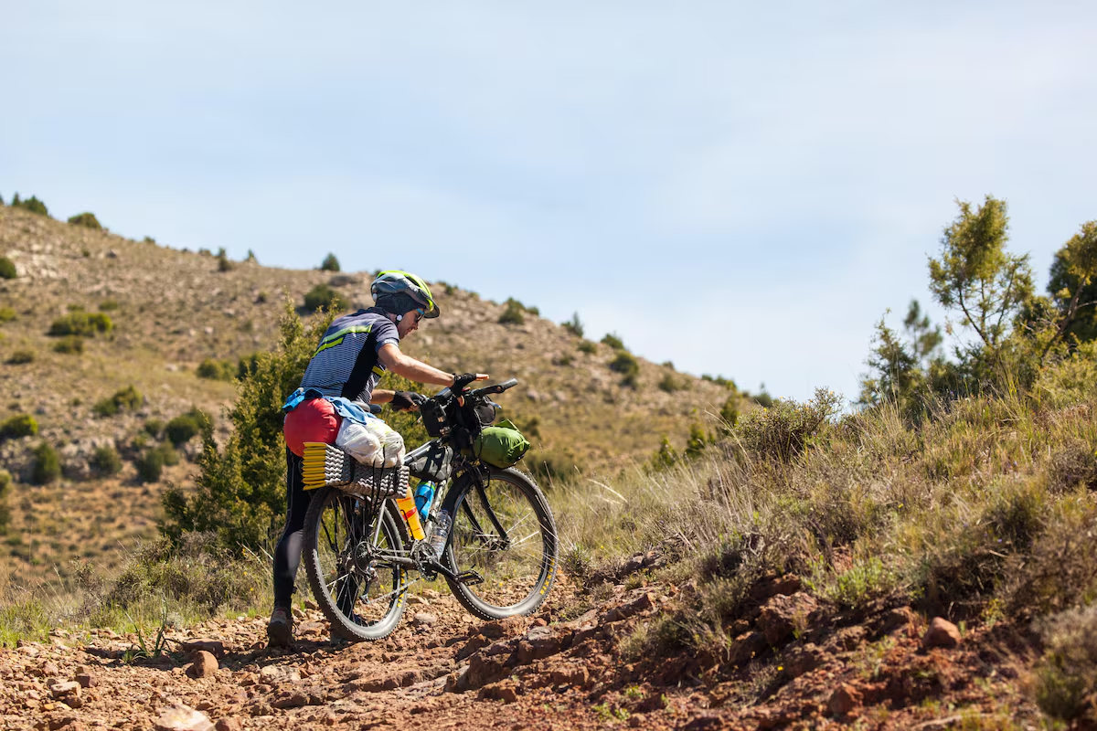
There are accommodations in Torres de Albarracín, but until Peralejos de las Truchas, the end of the third stage, there are no others. That is to say… 82 kilometers without the possibility of accommodation or supplies; too much to walk. This is why this route is more suitable for cycling. Hikers can go on day hikes, with spectacular stretches through the stone canyons. But all of this, unless you bring a tent and enough supplies, is impossible.
Peralejos de las Truchas is a small resort with a certain charm, good examples of popular architecture and all kinds of amenities for the night. A fountain in the square commemorates the writer José Luis Sampedro and his novel The river that takes usa delightful portrait of the gancheros who lowered logs along this stretch of the Tagus River to Aranjuez and Toledo, later turned into a film by Antonio del Real, who shot many scenes in the town.
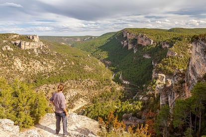
Here begins the fourth stage, perhaps the most spectacular of all those that travel along the Alto Tajo. The open spaces of the Scots pine give way to what will be the characteristic of the following kilometers: the deep canyons on the limestones and dolomites of the Montes Universales that the water has carved out for millions of years. The ravines and ravines of the Alto Tajo can be up to 200 meters deep. Its stepped shape is the result of the different resistance to erosion of the different materials that compose it. The river and the natural path are part of the system of gorges that have made the Alto Tajo a place of exceptional landscape and ecological value. The red and white trail markers of the Nature Trails network lead through a beautiful environment, which invites you to stop often to enjoy it.
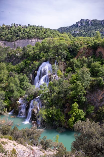
We then cross the Taravilla lagoon, a crystalline backwater formed by a natural barrier of limestone tuff that dams the waters of the streams, preventing them from reaching the Tagus. It is one of the most beautiful places of all the stages. Then, the signs lead you to cross the river, which has already significantly increased its flow, on a suspension bridge, just before reaching Poveda de la Sierra, the end of the fourth stage, where there are also services of all kinds.
The fifth day takes us from Poveda to Zaorejas through a similar environment: the Tagus sandwiched between huge walls and escorted by a riverine forest. Beyond Zaorejas the deep canyons of the Alto Tajo end to definitively enter more open and anthropized spaces where agriculture dominates. In total, from Albarracín to Zaorejas there are 160 kilometers along comfortable dirt roads without major gradients, which can be covered on two wheels in three days. You have to plan a way to get back to the starting point because, as I said, it is a linear route through emptied Spain and there is no public transport of any kind.
If you feel like it, the Tagus Route continues for another 650 kilometers to the border with Portugal to complete the great adventure of crossing Spain following the longest of its canals.